Completing the picture: The future of hydraulic modeling is two dimensional
March 02, 2021
March 02, 2021
2D modeling brings more clarity to the impact of hydraulic flows on critical infrastructure
At a time when climate change has made weather events more severe and unpredictable, hydraulic flows can have a serious impact on communities and infrastructure. Understanding and predicting the effects can prove difficult. In working to develop designs that help communities adapt and become more resilient against such risks, engineers seek to answer these questions using hydraulic modeling technology to analyze the impact of water flows.
Yet the technology available today remains deficient when it comes to modeling complex terrains and infrastructure, which can cause uncertainty when trying to implement lasting solutions. In response to this challenge, we adopted a two-dimensional (2D) modeling software that would give our team and clients more accurate and actionable information to solve these complex issues.
For decades, creating hydraulic models has meant using a program called HEC-RAS, which creates 1-dimensional (1D) renderings. Developed by the Army Corps of Engineers in the late ’90s, the program became the unofficial industry standard for hydraulic modeling, as it is free and easily available.
At the time it was released, HEC-RAS was the first system that could create a visual model of water flows, allowing engineers to create basic stream and hydraulic models.
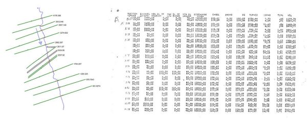
A HEC-RAS model, left, compared to HEC-2 numerical printout.
While providing a basic visual, the HEC-RAS technology offered a significant improvement compared to earlier tools. Prior to its release, hydraulic engineers had to rely on a system called HEC-2, which generated a numerical printout and 1D model with minimal details.
The release of HEC-RAS gave hydraulic engineers the first visual representation of hydraulic flow, albeit in thin, 1D slices. It gives a more user-friendly method of modeling basic streams and flows that is easier to understand than a HEC-2 numerical read out.
When working with complex terrain, however, creating models with HEC-RAS can be a challenge and, in some cases, almost impossible. This was the case on a project for the Mississippi Department of Transportation (MDOT). Our project team was tasked with determining whether three sets of US Interstate 20 bridges that cross Lynch Creek in Jackson were scour critical—that is, figuring out whether they would withstand a 100-year flood event. Bridges that are scour critical are at risk of losing structural integrity during heavy flooding and could collapse.
2D modeling allows us to create more complex topographies that provide more information and are easier to understand.
For a project with a single bridge, HEC-RAS would work well. In this case, however, we had to model bridges that ran underneath other bridges. Because a 1D model only displays a small slice of the area, it would be incredibly difficult, if not impossible, to complete a model using HEC-RAS, as it wouldn’t accurately detail the affect water flows have on the structures.
So, we decided to do something completely different for the Lynch Creek project—we went 2D.
We needed a method of modeling that could generate an aerial view of the project area so we could better understand the impact of a major flood event on the three bridges. This required a tool that would let us create a 2D model.
Advances in computer technology and processing power allowed us to implement a 2D modeling program into our tool kit, something that simply was not possible 20 years ago. 2D modeling allows us to create more complex topographies that provide more information and are easier to understand. Compared to the HEC-RAS model above, here is what a 2D model looks like:
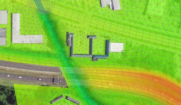
Here we can see a complete view of the terrain, the bridges, surrounding structures, and the creek. Though in its infancy, 2D modeling technology represents the future of hydraulic modeling with significant benefits over HEC-RAS.
In project areas like Lynch Creek, there are serious challenges in modeling with HEC-RAS. As mentioned, the project area had bridges overlapping other bridges. If we’d used HEC-RAS for Lynch Creek, we would have had to combine structures in the model, overlapping the bridges to complete the picture, but it wouldn’t have given us the information we needed. There would be parts of the model where we would have had to make assumptions about water flows. When it comes to determining the structural integrity of a bridge, guessing won’t cut it.
For example, a 1D model would be able to show the velocity of a water flow but not the vector. That is, it can show the force of the water but not the exact location it will affect.
With a 2D model, we’re able to see both the water flow velocity and a vector, which is vital in determining whether a bridge is scour critical.
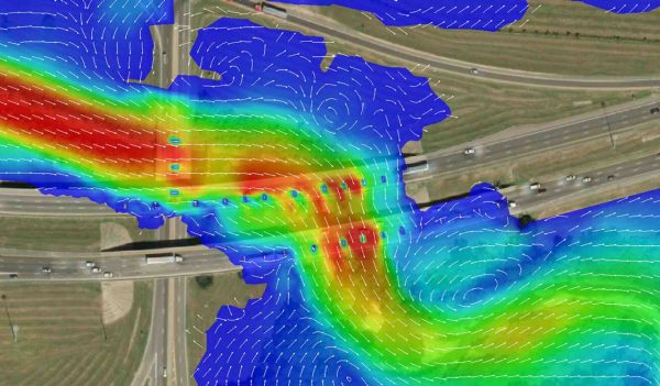
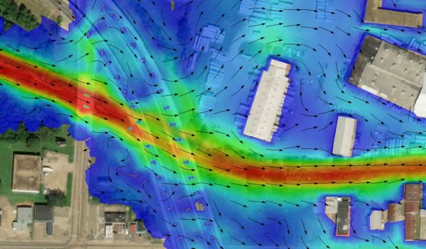
A 2D model inserted over an aerial image of the Lynch Creek bridges. This shows the exact angle and intensity of the flows attacking each pier and pillar, which provides a more accurate result.
2D models aren’t only easier to understand, they are easier to create.
In HEC-RAS, you need to make several assumptions with ineffective areas, such as bridges and culverts, where flow is not conveyed. These are educated guesses, of course, but guesses all the same. HEC-RAS also requires the input of a significant number of variables, all of which can have different interpretations depending on the engineer. For example, to add one building into a model, hydraulic engineers need to take several detailed measurements and enter multiple coordinates for different parts of the structure. Once entered, the program still only shows a sliver of the actual building in the final rendering. Thus, the program requires a great deal of work to generate a model and the final product isn’t necessarily 100%accurate.
Each bridge pier in HEC-RAS requires an engineer to manually input its dimensions. With 2D modeling, you simply draw what you see. The program allows you to draw the footprint of the pier, which is often supplied by the survey files. This streamlines the modeling workflow while also providing a more accurate and detailed model.
If you use HEC-RAS models on a regular basis, you understand the 1D renderings. One of the biggest challenges with any project is explaining a model to the public and clients. The 2D model below shows the velocity contours and vectors for a bridge during a 100-year event. It clearly depicts the topography and structures, as well as the water flow and intensity. This provides and easy-to-understand visual that hydraulic engineers can use to explain their findings to clients and the public.
The 2D model of a project provides a much better tool for engineers to explain their work to the public and clients than the HEC-RAS images, which simply feature lines.
While 2D modeling has numerous advantages over 1D, development and adoption of this technology has been slow. Given that HEC-RAS is free and easily available to the public, it has been ingrained in the industry as the standard for modeling. Nevertheless, the future of hydraulic modeling is two dimensional for two reasons—it’s easier and can handle much more complex issues.
Our team adopted a 2D-modeling program because it was essential to completing a project and, in the process, we discovered that the technology has the potential to revolutionize hydraulic engineering. The program generates highly interactive models that allow engineers to learn more about a project area while making it easier for those outside of the industry to understand the findings.
Beyond scouring, 2D modeling has applications in flood-plain modeling for rivers and streams, as well as roadway hydraulics. The technology is finally available to make these programs a reality. It’s only a matter of time before they become the new industry standard.