Fully aware: How to track air pollutants and GHG emissions with near real-time data
September 23, 2021
Select your region to visit a Stantec regional site, or visit our Locations Hub on our Global site where you can learn more about Stantec in your local area.
", "languageSelectorImage": { "imageLarge": "\/content\/dam\/stantec\/images\/Icons\/Map.svg" }, "globalRegion": { "name": "Global", "regionTag": "localization:global", "description": "", "languages": [ { "langCode": "en", "name": "English", "pathLink": { "url": "en" }, "active": "true" }, { "langCode": "fr", "name": "Français", "pathLink": { "url": "fr" }, "active": "false" } ] }, "regionLanguages": [ { "regionTag": "localization:china", "name": "China", "description": "", "languages": [ { "langCode": "en", "name": "English", "pathLink": { "url": "cn" }, "active": "false" }, { "langCode": "en", "name": "", "pathLink": { "url": "en" }, "active": "false" } ] }, { "regionTag": "localization:italy", "name": "Italy", "description": "", "languages": [ { "langCode": "it", "name": "Italiano", "pathLink": { "url": "it" }, "active": "false" }, { "langCode": "en", "name": "", "pathLink": { "url": "en" }, "active": "false" } ] }, { "regionTag": "localization:latin\u002Damerica", "name": "Latin America", "description": "", "languages": [ { "langCode": "es", "name": "Español", "pathLink": { "url": "es" }, "active": "false" }, { "langCode": "en", "name": "", "pathLink": { "url": "en" }, "active": "false" } ] }, { "regionTag": "localization:netherlands", "name": "Netherlands", "description": "", "languages": [ { "langCode": "nl", "name": "Nederlands", "pathLink": { "url": "nl" }, "active": "false" }, { "langCode": "en", "name": "", "pathLink": { "url": "en" }, "active": "false" } ] }, { "regionTag": "localization:taiwan", "name": "Taiwan", "description": "", "languages": [ { "langCode": "zh_tw", "name": "繁體中文", "pathLink": { "url": "zh_tw" }, "active": "false" }, { "langCode": "en", "name": "", "pathLink": { "url": "en" }, "active": "false" } ] }, { "regionTag": "localization:turkey", "name": "Turkiye", "description": "", "languages": [ { "langCode": "tr", "name": "Türkçe", "pathLink": { "url": "tr" }, "active": "false" }, { "langCode": "en", "name": "", "pathLink": { "url": "en" }, "active": "false" } ] } ], "originPath": "/content/stantec/en/ideas/content/blog/2021/fully-aware-how-to-track-air-pollutants-and-ghg-emissions-with-near-real-time-data.html" }, "locationSelector": { "locationInformationText": "We\x27ve detected you are located in", "locationDropdownText": "Please select your location", "changeLocationText": " Change location", "locationSaveText": " Save location", "learnMoreText": "Learn how we use this information", "regions": [ { "tag": { "tagID": "localization:africa" }, "title": "Africa" }, { "tag": { "tagID": "localization:australia" }, "title": "Australia" }, { "tag": { "tagID": "localization:belgium" }, "title": "Belgium" }, { "tag": { "tagID": "localization:caribbean" }, "title": "Caribbean" }, { "tag": { "tagID": "localization:china" }, "title": "China" }, { "tag": { "tagID": "localization:czech\u002Drepublic" }, "title": "Czech Republic" }, { "tag": { "tagID": "localization:germany" }, "title": "Germany" }, { "tag": { "tagID": "localization:global" }, "title": "Global" }, { "tag": { "tagID": "localization:india" }, "title": "India" }, { "tag": { "tagID": "localization:italy" }, "title": "Italy" }, { "tag": { "tagID": "localization:latin\u002Damerica" }, "title": "Latin America" }, { "tag": { "tagID": "localization:middle\u002Deast" }, "title": "Middle East" }, { "tag": { "tagID": "localization:netherlands" }, "title": "Netherlands" }, { "tag": { "tagID": "localization:new\u002Dzealand" }, "title": "New Zealand" }, { "tag": { "tagID": "localization:north\u002Damerica" }, "title": "North America" }, { "tag": { "tagID": "localization:slovakia" }, "title": "Slovakia" }, { "tag": { "tagID": "localization:taiwan" }, "title": "Taiwan" }, { "tag": { "tagID": "localization:turkey" }, "title": "Turkiye" }, { "tag": { "tagID": "localization:united\u002Dkingdom" }, "title": "United Kingdom" } ], "currentRegion": "Global", "learnMoreLink": { "url": "\/en\/copyright.html", "target": "" } }, "searchBar": { "searchPageLink": { "url": "\/en\/search.html" }, "labels": { "searchInputLabel": "Search Input", "searchBarPlaceholder": "What are you looking for?", "closeButton": "Close Button", "suggestionsFooter": "Search for results", "noSuggestions": "No suggestions found" }, "searchBarSuggestions": { "endpoint": "/bin/suggestions.json", "currentPath": "\/content\/stantec\/en\/ideas\/content\/blog\/2021\/fully\u002Daware\u002Dhow\u002Dto\u002Dtrack\u002Dair\u002Dpollutants\u002Dand\u002Dghg\u002Demissions\u002Dwith\u002Dnear\u002Dreal\u002Dtime\u002Ddata" } }, "languageSelectorModal": { "languageSelectorTitle": "Language \/ Region", "languageSelectorDescription": "Select your region to visit a Stantec regional site, or visit our Locations Hub on our Global site where you can learn more about Stantec in your local area.
", "languageSelectorImage": { "imageLarge": "\/content\/dam\/stantec\/images\/Icons\/Map.svg", "altText": " World map" }, "globalRegion": { "name": "Global", "regionTag": "localization:global", "description": "", "languages": [ { "langCode": "en", "name": "English", "pathLink": { "url": "en" }, "active": "true" }, { "langCode": "fr", "name": "Français", "pathLink": { "url": "fr" }, "active": "false" } ] }, "regionLanguages": [ { "regionTag": "localization:china", "name": "China", "description": "", "languages": [ { "langCode": "en", "name": "English", "pathLink": { "url": "cn" }, "active": "false" }, { "langCode": "en", "name": "", "pathLink": { "url": "en" }, "active": "false" } ] }, { "regionTag": "localization:italy", "name": "Italy", "description": "", "languages": [ { "langCode": "it", "name": "Italiano", "pathLink": { "url": "it" }, "active": "false" }, { "langCode": "en", "name": "", "pathLink": { "url": "en" }, "active": "false" } ] }, { "regionTag": "localization:latin\u002Damerica", "name": "Latin America", "description": "", "languages": [ { "langCode": "es", "name": "Español", "pathLink": { "url": "es" }, "active": "false" }, { "langCode": "en", "name": "", "pathLink": { "url": "en" }, "active": "false" } ] }, { "regionTag": "localization:netherlands", "name": "Netherlands", "description": "", "languages": [ { "langCode": "nl", "name": "Nederlands", "pathLink": { "url": "nl" }, "active": "false" }, { "langCode": "en", "name": "", "pathLink": { "url": "en" }, "active": "false" } ] }, { "regionTag": "localization:taiwan", "name": "Taiwan", "description": "", "languages": [ { "langCode": "zh_tw", "name": "繁體中文", "pathLink": { "url": "zh_tw" }, "active": "false" }, { "langCode": "en", "name": "", "pathLink": { "url": "en" }, "active": "false" } ] }, { "regionTag": "localization:turkey", "name": "Turkiye", "description": "", "languages": [ { "langCode": "tr", "name": "Türkçe", "pathLink": { "url": "tr" }, "active": "false" }, { "langCode": "en", "name": "", "pathLink": { "url": "en" }, "active": "false" } ] } ], "originPath": "/content/stantec/en/ideas/content/blog/2021/fully-aware-how-to-track-air-pollutants-and-ghg-emissions-with-near-real-time-data.html" } }September 23, 2021
Q&A: Two Stantec atmospheric science experts discuss how a new platform can help companies deal with regulatory challenges and meet GHG reduction targets
It’s time. If you’re not adequately understanding and addressing your air pollutants, including greenhouse gas (GHG) emissions, it’s time to fix that. Pollutants have become an operational and reputational risk for many companies, as governments around the globe tighten regulatory compliance and requirements to align with emission protocols—like COP26 and the Paris Agreement.
It’s important to manage and mitigate your emissions for a few reasons:
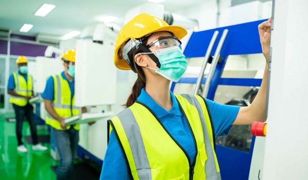
AirLogic monitors airborne pollutant levels from manufacturing facilities.
To help companies understand and address their emissions and pollutants, Stantec has partnered with BlueSky Resources, on their application AirLogic™. A leading industry provider of air quality and emissions-tracking data, BlueSky’s software, atmospheric, and data-science specialists use a global network of independent sensor technologies to produce near real-time emission and air pollutant data, all in one place, outstripping traditional industry speeds.
AirLogic aggregates and organizes data and analytics to create a single-source dashboard with daily, weekly, quarterly, and yearly views of emissions and concentrations of critical air pollutants, GHG’s, and particulates for targeted facilities.
Accessed from your desktop, AirLogic consolidates global ground sensors, regional sensors, and satellite network-related data in one database. Users can create custom alerts to be promptly notified of unusual, emerging conditions around facilities—either from a specific location or a system of facilities. This data can inform compliance and investor reporting and early communication with regulatory authorities and the public.
AirLogic can be used in a variety of industries, including agriculture, manufacturing, mining, oil and gas, power, and waste management. The platform helps companies meet regulatory requirements, reduce costs, and improve the health and safety of their employees.
Curious about how it works? To discuss AirLogic, Stantec’s Kevin Madry and Reid Person decided to share what they’re learned about using the innovative platform.
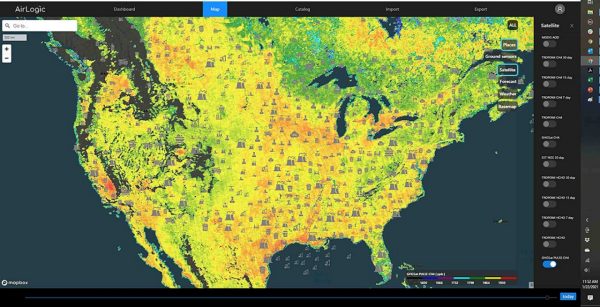
The AirLogic intuitive visual interface is easy to navigate. (Image courtesy of GHGSat 2021)
Reid: It’s a Google Earth-driven platform. It functions like Google Maps, with many air-quality-related data layers from ground-based monitoring systems, sensors, etc. It then combines other Google Earth-based layers that are available, along with satellite-based remote sensing data. It can also add any other data sets that someone has available and wants to ingest into the system.
Really, one of the unique capabilities of this system is the availability of a wide range of satellite-based remote sensing air quality data. AirLogic makes satellite and other remote sensing data available in an easy-to-use platform, whereas in the past that data could be disparate and difficult to find and use.
Kevin: There are lots of potential applications for mining. But here’s a scenario we’ve discussed: Say you’re a mining company that’s having trouble with dust events. Perhaps you’ve received complaints because the dust from your mine is traveling to nearby residences and landing in people’s yards. AirLogic allows you to use data analytics to identify the underlying causes of dust events and then forecast them, allowing you to plan, forecast high wind events, and perform dust suppression when it makes the most sense.
AirLogic makes satellite and other remote sensing data available in an easy-to-use platform, whereas in the past that data could be disparate and difficult to find and use.
Reid: Think about oil and gas clients that operate in remote areas. AirLogic could work as a tool to aggregate existing monitoring data—but also to leverage remote sensing satellite data capabilities. You could use satellite-based air quality and monitoring data to provide an indication of air quality over large expanses of the desert, for example. It can be very difficult, logistically, to monitor wide uninhabited areas where you don’t have monitoring equipment deployed. So, the value for monitoring and managing is an easy case to make.
Reid: For waste management, AirLogic allows you to identify and manage your GHG emission risk. This platform can consolidate different types of emission monitoring data from multiple landfills. Typically, this data (surface-emission monitoring, drone surveys, aircraft surveys, fixed-sensor data) is collected in different ways and via different formats, so AirLogic lets you centralize everything in a single platform. I’m not aware of another tool on the market that can ingest multiple types of data, create visualizations, and infer trends.
With this platform, you can compare landfill sites to each other and look at the data as a trend in time to understand how you’re doing and where you’re headed. Also, remote sensing data from satellites can be used to complement existing monitoring networks. The number of and capability of these satellites is growing exponentially. AirLogic makes this data available to industry.
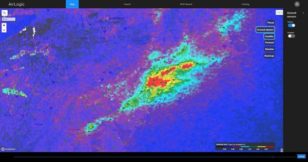
AirLogic displays imagery that detects the flow and intensity of airborne pollutants.
Reid: When it comes to value, you can certainly look at the potential for labor savings, of doing things better or more efficiently. But then there’s also the enterprise value—where you’re seen as managing your emissions and being responsible for them. It’s that shareholder return value or “goodwill” value.
Kevin: I just want to elaborate on what Reid’s saying here. There’s a lot of available data these days. And when it comes to the public, there’s a growing awareness of emissions pollution, GHGs, and carbon management. Customers can choose to buy from one company because it’s more environmentally conscious than another one. AirLogic can ensure that you are aware of the latest data about your facility. That way, you can anticipate any issues and respond promptly when someone asks you about your latest data.
Kevin: Well, there’s the capability to export. You can zoom in and get your data and see the measurements via satellite or monitors at a particular day and time. Then, you can export that data and manipulate it even more if you like.
Kevin: It reminds me of when the iPhone first came out. When smartphones arrived, it took some time for people to play around with them and see the value of looking at things in a different way.
After a while, a smartphone became something that most people can’t live without. Now, I can’t imagine getting into a car in a new city and not having access to a map application to help me navigate. Much the same, I can’t imagine not using AirLogic to provide the most comprehensive, timely, and accurate data to our clients.