How can technology protect against extreme weather events?
September 12, 2022
September 12, 2022
Our team of experts has a suite of remote sensing tools that can help us respond to the impacts of climate change. Here’s how.
One of the most noticeable impacts of climate change is the increase of extreme weather events. And not only are these events becoming more frequent, but they are also becoming more severe. From hurricanes, storms, and floods, to heatwaves, drought, and wildfires—we have been experiencing an influx across the board.
Extreme weather events can have a tragic impact on people. Look no further than Hurricane Katrina to understand just how much of a toll events like that have on local communities. But they also have significant impacts on infrastructure. Katrina did more than $125 billion in damages to New Orleans and the surrounding area.
As the world continues to warm, we as an industry need to understand how we can protect communities and infrastructure against these kinds of events. After all, they don’t seem to be letting up any time soon. Hurricanes in the south, flooding in the east, wildfires in the west, and winter storms in the north—we are facing an onslaught of extreme weather that changes from region to region.
The good news? We have the tools and technology to help protect us against these climate risks. Maybe we can’t prevent storms like Katrina from happening, but we can try to mitigate the impacts. From protecting transmission and distribution lines against wildfires, to monitoring melting permafrost in warming northern regions, to assessing for geohazards after severe storm events—our teams use remote sensing technology to help protect communities and infrastructure around the world.
Let’s look at some examples below.
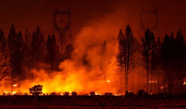
Flames encroach upon a set of transmission lines.
One of the biggest climate challenges we are seeing is drought. Drought occurs when there is a significant lack in precipitation. And when it gets dry enough, the potential risk of wildfires increases.
Wildfires are particularly damaging to our communities. Not only do they burn through everything in sight, but they cause terrible smoke and air quality conditions. Wildfires also impact our infrastructure too, especially when it comes to power lines. Damage to our transmission and distribution lines can leave communities without power for days.
But ironically, power lines can also cause wildfires. When dry vegetation encroaches on our power lines, there is the potential that the electricity running though the lines can spark a bush fire. If it is especially dry due to drought-like conditions, these fires can spread rapidly and be incredibly hard to extinguish.
This is where our team comes in. We help utility providers monitor their distribution network to make sure that no vegetation is intruding on the electrical infrastructure. How? By employing a revolutionary tool called WireWATCH™.
As the world continues to warm, we as an industry need to understand how we can protect communities and infrastructure against these kinds of events.
WireWATCH™ helps us monitor transmission lines for vegetation encroachment that can lead to power outages and wildfires. By harnessing the power of geographic information systems and satellite imagery, we can quickly evaluate thousands of miles of power lines. Not only does this approach give us near real-time analytics, but it eliminates the need to monitor in person—saving time and money in the process.
We can only assume that the issue of drought is likely to get worse. As such, we must work to ensure that our transmission and distribution lines are free and clear from vegetation. WireWATCH™ is a great tool that is helping to protect communities against power outages and wildfires.
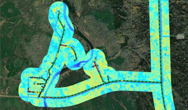
WireWATCH™ helps us monitor transmission lines for vegetation encroachment that can lead to power outages and wildfires.
Another climate challenge we are facing is warming in northern regions. Historically, the northern landscapes in Canada and the US (Alaska) have been frozen solid. But as the world continues to warm, so too do the northern regions. Look no further than the Arctic, where polar ice caps have been melting at a noticeably increasing rate.
Warming in the north has significant impacts on people and wildlife. It negatively affects the fishing industry and displaces animals like polar bears. But just like storms, warming can impact infrastructure too. We have especially noticed this on the Trans Alaska Pipeline System (TAPS), which transports oil from the northern tip of Alaska to the southern shore for transport.
More than half of the TAPS runs above ground—an engineering decision due to Alaska’s prevalent permafrost terrain. The design relies on a thick layer of subsurface permafrost to function as a foundation for the pipeline supports. But what happens when that permafrost begins to thaw? The integrity of the pipeline can be compromised and the potential for leaks or spills increases.
Pipeline operators can combat this challenge with thermosyphons. Thermosyphons are long cylinders that are driven into the ground along pipeline routes to extract heat and keep the permafrost, well, frozen. So, how can we identify the areas in need of these thermosyphons? By using Interferomic Synthetic Aperture Radar (InSAR).
InSAR is a remote sensing technology that uses satellite imagery to scan the ground at various phases. It provides an accurate and precise assessment of surface movement over time. This tool is helpful when monitoring permafrost because it allows us to identify areas in need of intervention.
If we understand where the permafrost is thawing due to warming conditions, we can help our clients to manage this issue and prevent against potential leaks or spills.
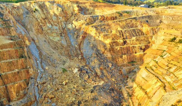
An open-pit mine experienced a landslide that collapsed one of the walls used for transporting ore.
We all know that severe storms and flooding events can have significant impacts on our energy and resources infrastructure. And this problem has been persistent throughout the industry. Transmission lines, power generation, pipelines, mines, and dams are all at risk during hurricanes and extreme storms. But they are also more vulnerable after these kinds of events. Why? Because these storms can shift the ground formation and cause geotechnical and hydrotechnical hazards.
Geotechnical and hydrotechnical hazards can include geohazards like landslides, erosion, karst (soluble rock formations), and watercourse crossings. The potential of these hazards increases after storms—and after wildfires too. And when the ground formation shifts enough, it poses a threat to our infrastructure. So, we use our in-house tool—GroundWATCH™—to monitor areas of geotechnical risk.
GroundWATCH™ uses InSAR data paired with high-resolution imagery and Light Detection and Ranging (LiDAR) data. This combination allows our team to derive bare-earth digital elevation models. These help us to identify, delineate, and prioritize potential geohazards around our energy and resources infrastructure.
By employing this technology, we can help keep communities and energy infrastructure safe from post-storm ground deformation. From protecting our pipelines from potential leaks, to monitoring steep areas around dams and mines for landslides, to simply keeping the lights on— GroundWATCH™ can be utilized in many areas of the energy and resources industry.
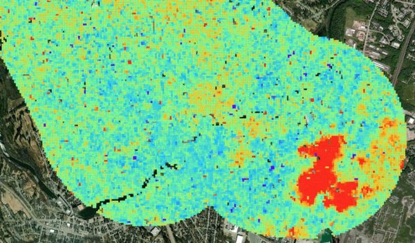
GroundWATCH™ uses InSAR data paired with high-resolution imagery and Light Detection and Ranging (LiDAR) data.
Like we said earlier, the prevalence of extreme weather events only seems to be increasing. We are seeing climate challenges in almost every region of North America, from flashing freezing in Texas to heating temperatures in the Arctic. While the industry works to reduce global GHGs—and hopefully taper the number of extreme weather events occurring in the world—there are plenty of opportunities to use remote sensing technology and mitigate the impacts to our energy and resources infrastructure.
From protecting transmission and distribution lines, to monitoring melting permafrost, to surveilling energy infrastructure for geotechnical risks, remote sensing technology empowers our teams with timely, accurate, and reliable data.