Measuring trees and tracking carbon sequestration from the sky
August 30, 2022
August 30, 2022
Remote sensing—via planes, drones, and satellites—offers a quicker, less costly way to count the benefits of carbon sequestration
Imagine for a moment that your company or organization owns a tract of undeveloped land and you’re wondering how it will fit into your net zero goals or your environment, social and governance (ESG) plan.
In the battle against climate change, greenhouse gas emissions are the main target. That tract of land might provide an opportunity to trap and store carbon dioxide, a process otherwise known as carbon sequestration.
This process is when trees, shrubs, grasses, and other plants use photosynthesis to capture and store carbon dioxide in their trunks, branches, stalks, and roots. Forest, grassland, and coastal wetland carbon sequestration acts as a “carbon sink” and helps to offset other greenhouse gasses in the atmosphere.
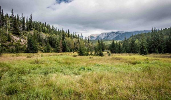
Landowners across the globe are looking to their forests as environmental, sustainable, or governance assets. Remote sensing can help measure your forest’s growth over time.
For energy, natural resources, mining, and other organizations around the world, plants and soils can be critical tools in combatting climate change or achieving their carbon-emission reduction goals.
For example, if your tract of land has an existing forest that is being impacted, or if you’re thinking of reforesting an industrial site, two important questions may come to mind: How do I measure how much carbon dioxide is stored on my tract of forest? And can I enhance that carbon sequestration over time through changes in management or investment in restoration?
Those questions are increasingly being answered by using remote sensing tools and technology. Satellites, planes, and drones that fly over the land and collect data help provide those answers.
By using remote sensing, we can now get data on tree species, crown diameter, tree height, and the number of trees present. And with that data, we can use scientific models to estimate how much biomass is in the forest. We can track increases in biomass can over time and calculate how the area of interest is benefiting the Earth’s climate through carbon storage.
No matter if the site is a few acres or tens of thousands of acres, remote sensing is a cost-effective way to inventory forests, grasslands, and other ecosystems and calculate their worth in the battle against climate change. With that data, we can quantify whether your forest or reclamation project is tracking with your ESG strategies and net zero goals.
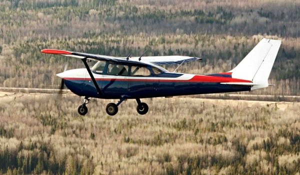
Airplanes, paired with LiDAR equipment, provide remote-sensing capabilities to survey forests and the carbon they store.
We recently conducted a tree survey using remote sensing for an industrial reclamation client in Canada who had planted trees as part of a land rehabilitation project.
The remote reclamation was only accessible by plane, making a tree-survey crew expensive and time-consuming for the company.
With so-called “boots-on-the-ground” surveys, a crew counts trees in distinct plots and measures their size, making note of other vegetation in the area. Field-based vegetation measurements only cover a fraction of the total biomass, and companies are forced to extrapolate readings over many square miles resulting in potentially inaccurate data.
With the remote industrial site, we worked with a pilot and crew, using LiDAR equipment to survey the trees on the reclaimed site. Using remote sensing allowed the actual survey to be completed in a single day, and the LiDAR data was available in less than two weeks.
We collected vital biomass information with millimeter accuracy of every single planted tree, shrub, and grass community across many square miles. Using a plane and LiDAR equipment, we were able to greatly reduce the costs of surveying the reclamation site.
No matter if the site is a few acres or tens of thousands of acres, remote sensing is a cost-effective way to inventory forests, grasslands, and other ecosystems and calculate their worth in the battle against climate change.
LiDAR gives us a remarkable amount of information about vegetation. Using object-based image analysis, we can determine the maturity and size of trees. We can detect the difference between a tall red pine and shorter, scrubby jack pine. Infrared can tell us even more about tree species—whether it is a birch and spruce, for example. With textual and spectral reflectance, we can survey forests of multiple species and accurately identify specific trees.
Stantec’s ExtractX™ remote-sensing tool can also measure growth of trees over time, providing important data on a forest’s rising value as a carbon sink. Remote-sensing technology can tell everything we need to know about trees and vegetation, except maybe the roots, which we can estimate given published ratios of above- to below-ground biomass.
All this data is available around the world at multiple sites without putting boots on the ground.
If you are interested in how your climate goals fit with United Nations Sustainable Development Goals, look no further than Goal 13 and Goal 15. Carbon capture strategies fulfill UN Goal 13, which focuses on climate action. UN Goal 15 looks at preserving diverse forms of “life on land” and identifies managing forests sustainably. The key to succeeding in Goal 13 and 15 is collecting data that demonstrates that managed, preserved, enhanced, and restored habitats are providing increased benefits for the planet relative to a baseline. Remote sensing allows you to do that in a way that is efficient and effective.
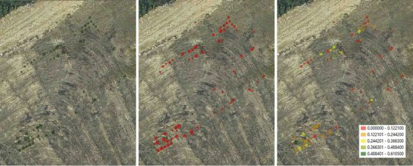
In this series of photos, the Stantec remote sensing tool, ExtractX™, was used to delineate and quantify reclaimed tree and shrub plant height, crown diameter, structure, biomass volume, and species.
Our Canada client didn’t undertake their forest-reclamation survey to measure carbon capture effectiveness or an ESG goal. The goal was to survey the forest planting to determine its success and growth. This type of approach can also potentially generate value in the form of ESG goal fulfillment when the project activity exceeds or is separate from a regulatory requirement.
Landowners across the globe are looking at their forests as ESG assets. Some are taking vacant lots or redundant property—property that they are already paying taxes on—and planting trees or other vegetation.
Some are purchasing tracts with a history of planned or unplanned timber harvesting to preserve the carbon resources onsite and augment their portfolio of carbon-storing assets. In all cases, remote sensing and collecting data makes those efforts easier, especially in remote regions, by providing data on how the land is performing.
Some landowners are unaware that they have climate-change assets locked away on their property, waiting to be quantified, and in many cases improved upon.
This blog was featured in the Environmental Journal.