From Stantec ERA: Monitoring pipelines from space
July 15, 2020
July 15, 2020
Understanding where and when a pipeline leak has occurred via satellite technology
Energy & Resource projects come with their own set of arduous challenges before, during, and after the construction process. Maintaining the integrity of these projects throughout their lifecycle is critical, particularly when it comes to Oil & Gas pipelines.
If a pipeline leak occurs, it can have several environmental, social, and economic impacts for pipeline operators and the communities they serve. Leaks can harm the natural environment as well as the wildlife living in it. They can impact the safety of surrounding communities in the area. Leaks can also cost pipeline operators their time, money, and ability to compete for work. That’s why we employ measures to safeguard the Oil & Gas industry against the risk of pipeline leaks.
Thanks to innovation, many new pipelines have the luxury of built-in technology that digitalizes operations and maintenance via fiber-optic cables. But many of the pipelines we need to monitor are already in the ground—some have been buried for more than 50 years!
Traditionally, pipeline operators have monitored buried pipelines via ground or aerial patrol, examining the land for any visible changes to the earth. But those methods can be timely, costly, and sometimes ineffective—especially because pipeline leaks require urgent action to minimize impact to the surrounding environment.
So, now the industry is turning to remote sensing, satellite imagery, and tools like PipeWATCH to help them find leaks more efficiently.

Traditionally, pipeline operators have monitored buried pipelines via ground or aerial patrol. Now the industry is turning to remote sensing, satellite imagery, and tools like PipeWATCH to help them find leaks more efficiently.
Remote sensing specialists work to analyze images captured above Earth’s surface. Why? To give our clients a deeper understanding of our planet and how it changes over time.
In recent years, remote sensing specialists have relied on satellites to take photos of Earth continuously throughout the day. We use this imagery to better understand the environment and make more informed decisions about almost anything related to Earth’s surface. Now, we use this satellite imagery to help monitor aging pipeline infrastructure for leaks.
In the past few years, remote sensing technology has evolved significantly. Thanks to the development of small, inexpensive satellites, we can capture and examine images of the entire planet each day. These technological advancements have enabled our team to create PipeWATCH, a revolutionary remote sensing tool that helps us effectively monitor buried pipelines.
PipeWATCH can quickly help mitigate surface and subsurface releases by pinpointing exact locations of concern.
PipeWATCH is made possible by the power of small satellites, called Dove satellites, and their ability to take high-resolution images of the Earth’s surface. Traditional satellites are as large as a truck, but small satellites are less than the size a microwave. Rather than one big satellite, dozens of small satellites are launched into orbit and arranged in constellations, enabling them to capture more images at a higher resolution.
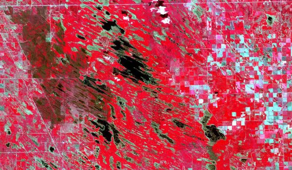
These small satellites acquire red, green, blue and near-infrared images to monitor vegetation that is growing above and around buried pipeline infrastructure. PipeWATCH then calculates highly sensitive vegetation health measurements on the pipeline right-of-way (ROW). Using change-detection analysis, PipeWATCH compares ROW vegetation health values from one day to the next, looking for signs of reduced vegetation health. A decline in vegetation health on a pipeline ROW could be caused by a release event.
Thankfully, PipeWATCH knows what patterns to look for and can analyze vast sets of images almost instantly. When we notice a significant change to the vegetation, we know that a leak may have occurred, and that action must be taken. The beauty of PipeWATCH is that it provides this information to us much faster than any other method.
PipeWATCH isn’t just able to tell us whether a leak exists; it can accurately tell us when and where it happened.
Thanks to our formal partnership agreement with Planet—the world leading satellite imagery provider—we can offer pipeline operators unprecedented satellite image fidelity and consistency. Our ability to access this data allows us to review images taken in real time to help us understand exactly when and where a leak is occurring.
As our ability to track changes on the surface of the earth improves, so does our ability to monitor aging pipeline infrastructure for the Oil & Gas industry and the communities it serves.
When a pipeline operator approached us to prove the effectiveness of the tool, we were eager to demonstrate it for them. They had been interested in PipeWATCH for some time, but they needed proof that the technology worked. So, they presented us with a pipeline leak that they had experienced earlier that year. They gave us a four-month time span and a 625-square-kilometer area to analyze—that was it! We had to use PipeWATCH to ascertain the rest.
The test for our team was to determine exactly where and when the spill had occurred in that four-month window. PipeWATCH can look back in time—via a historical satellite imagery archive—to study images that were taken in the months prior. The result? We established that the spill happened five days before our client had realized it. Had they used PipeWATCH, they could have responded to the leak five days earlier, giving them more time to mitigate any environmental, social, or economic impacts.

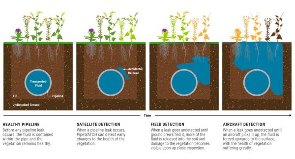
Captured by small satellites orbiting the globe, red-green-blue images reveal changes to the health of vegetation near pipeline routes. When we notice the color shifting from green to red, we know that a leak may have occurred. As time passes with a leak going undetected, there will be more damage to the vegetation.
Currently, the small satellites that PipeWATCH uses take images at a resolution of three metres per pixel. This is a significant improvement from two years ago, when we were only able to monitor Earth’s surface to a resolution of 10 meters. The technology is continually getting better, and by the end of 2020, we expect to look even closer at the surface of Earth with a resolution of 50 centimeters per pixel. This trend of greater and greater resolution will continue—we are striving for a 25-centimeter resolution by 2022.
As our ability to track changes on the surface of the Earth improves, so does our ability to monitor aging pipeline infrastructure for the Oil & Gas industry and the communities it serves.
