Predicting the unpredictable: How a Stantec toolbox helps us understand future flood risks
June 06, 2019
June 06, 2019
Stantec and clients are combining historic rainfall and climate data with the latest modelling tools to prepare communities for future weather events
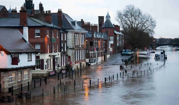
Rainy English weather is the punchline for a lot of jokes. But in the summer of 2007, nobody in the United Kingdom was laughing about the weather. That’s because the region experienced its wettest May through July since records began more than 200 years earlier. Parts of England received more than a month’s worth of rain in just 24 hours. Catastrophe followed. 13 deaths. Thousands homeless for months. A £3.2 billion (CAD$5.6 billion) economic hit.
Response to the storm events was swift and significant. Large-scale rescue operations were put into effect as the floodwaters surged. Yet it quickly became clear that the situation would have been better managed had authorities been better prepared. But how?
United Kingdom’s government passed the Flood and Water Management Act 2010 and increased funding for flood risk management to help ensure communities are prepared for extreme storm events.
There’s not an easy answer to that question. But a Stantec team in the United Kingdom is trying to help. They’ve developed a software solution to help water utilities better predict when and where floods may hit—and how big they may be.
“The nature of the storm made the floods of 2007 particularly bad,” explains Stantec principal engineer John Titterington (Warrington, United Kingdom). “The ground was already saturated, and then a great deal more rain came very quickly. This wasn’t a situation where authorities saw a river slowly rise and had time to evacuate their citizens.
“Those of us in the industry had long been working to understand how we could better prepare for and respond to floods. Suddenly, everybody was talking about it.”
The UK government increased spending on flood risk management and later passed the Flood and Water Management Act 2010, which takes a wide, rather than localized, view of drainage solutions and calls for increased collaboration between responsible bodies. The Act also advocates for the construction of sustainable drainage systems, including green infrastructure.
John lives near Manchester, in an area of flash flood risk. A civil engineer with a focus on urban drainage modelling, John enjoys walking and fishing along the local rivers and lakes of the Peak District National Park. These passions gave him a professional and personal motivation to consider how water utilities and other stakeholders could better predict and manage flooding and pollution.
John and his colleagues had an idea they thought could help. This Stantec team wanted to harness information that was already maintained in various databases—namely, historical rainfall records and radar rainfall data—and combine it with weather and climate forecasting and modelling tools to get a clearer picture of what levels of rainfall may occur in the coming decades and the impact they may have on catchments and communities.
The team’s idea—to bring together different datasets and tools in one place—was the beginning of Stantec’s rainfall and climate toolbox, a user-friendly application that provides a comprehensive set of tools to help clients analyze and prepare rainfall data and model catchment risks.
“Using one data source isn’t enough,” says John, who explains that often historical data is imperfect. “There can be periods of missing data, which have to be cleaned up and validated through a time-consuming process using information from near-neighbor rain gauges. We wanted to create a tool that could automate this process, and more.”
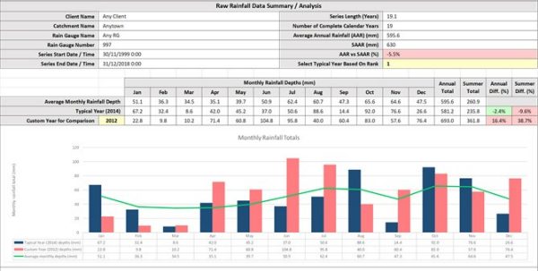
The rainfall and climate toolbox produces graphical displays that allow users to view large amounts of data at a glance. These displays help make complex data easy to understand and support efficient decision-making.
Anyone who watches the nightly news has an elementary understanding of rainfall data. That’s because meteorologists rely upon it to give the daily forecasts. Radar rainfall data—which estimates the intensity of expected storms and informs those colorful weather maps—provides an excellent spatial picture of where rain may fall, and how hard it may rage.
Radars, however, aren’t always great at capturing the rainfall intensity at the ground level. That’s where terrestrial rain gauges come into the picture. These devices use a tipping-bucket mechanism to more accurately measure point rainfall intensity at ground level in real-time.
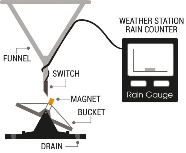
The diagram above illustrates the mechanism used for a standard terrestrial rainfall gauge.
By adjusting radar estimates based on point rain gauge measurements, it’s possible to combine the advantages of both sensors and to have a better spatial description as well as local accuracy of urban rainfall. This improved data can then be used to more accurately calibrate our models—leading us to a better understanding of flood ad pollution risks.
Several universities have undertaken research on the merging of radar rainfall and rain gauge data; Imperial College London has been at the forefront. John and the Stantec team got in touch with the school and found they had a piece of software that was able to bring the data sets together to create more accurate predictions of combined sewer overflows or flooding.
“We started our work on this software as part of a European Union-funded Interreg IVB project called RainGain,” says hydro-meteorologist and software developer Li-Pen Wang, who completed his doctoral studies at Imperial College and led the development of the merging software during his post-doctoral research. “Prior to this, consultants were using radar rainfall data to display historical events, but not as a model input. By increasing the accuracy of the data, we’ve improved predictability for consultants, utilities, and other industries, such as insurance.”
Impressed by its capabilities, the team linked the Imperial College London tool to the toolbox. But they didn’t stop there. Information is power—the team knew that the more information they could bring together, the better the toolbox would be, and so added
A rainfall generator, which uses historical records to generate long-term rainfall series of up to 200 years in length
A climate tool based on a high-resolution climate model created by the United Kingdom’s national weather service, the Met Office
The climate tool can prepare regional future weather predictions to inform users whether they should expect changes in the frequency or severity of thunderstorms, which are the main cause of flash floods in urban catchments. This helps decision-makers understand their risk exposure to make smart choices.
Stantec is currently using the rainfall and climate toolbox for clients in England and Scotland. The short-term benefits are already being realized.
“There’s no more ad hoc data cleanup in countless spreadsheets,” says John. “The process is faster, more consistent, and more transparent, with less room for user error. What used to take a day may now take a half-hour.”
The long-term results are trending positive, too. That’s because the toolbox is taking all that data and putting it into a user-friendly graphical interface. Clients can better understand their risks to assess infrastructure needs now and into the future.
“Nobody can know the future, of course,” says John. “But we can get a clearer picture of its potential using the best available research. Our clients are using the data from the toolbox to see far into the future. This is helping them test a range of scenarios, enabling them to make smart, adaptive, and flexible decisions about where to invest their repair, replacement, and operational management budgets.”
The toolbox can also help in flash flood events like those that occurred in 2007. Improved confidence in models, combined with rainfall forecasts, will enable authorities to better predict local floods. This will help them to manage risks in real-time through automated flood warnings, operational control of drainage infrastructure, by designing to accommodate flood waters, and through the management of flood waters on the ground.
“This collaborative work and the resulting tool will have a major impact on our industry,” says Chris Digman, a technical director at Stantec and visiting professor at University of Sheffield. “It deals with one of the critical components we have to work with in the industry, rainfall, and will support our clients—and ultimately the communities we serve—to manage risk through sound science and application, while reducing overall costs.”
Climate change—and the extreme weather events it brings—isn’t limited to the United Kingdom. That’s why the Stantec team thought globally when they built the rainfall and climate toolbox. The structure of the toolbox allows for the addition of new modules, so a climate model from any other country or region could easily be added.
“What started as an idea has become a reality,” says John. The development of the rainfall and climate toolbox was funded through Stantec’s Greenlight Program, which financially supports employees’ good ideas. “That’s because our Company believed in our idea and was willing to put its money toward designing a solution that would create real value for our clients, not just here in the United Kingdom, but around the world too. I can’t wait to see what happens next.”