Nebraska Department of Natural Resources selects Stantec to develop floodplain modeling and mapping
The project aims to improve resiliency in two of Nebraska’s most at-risk counties
06/29/2022 LINCOLN, NE TSX, NYSE:STN
The project aims to improve resiliency in two of Nebraska’s most at-risk counties
06/29/2022 LINCOLN, NE TSX, NYSE:STN
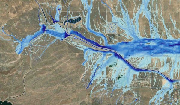
The Nebraska Department of Natural Resources (NeDNR) has selected leading global design firm Stantec to conduct floodplain modeling and mapping for Box Butte and Sheridan Counties. The project aims to improve resiliency throughout both counties by arming stakeholders with an advanced level of understanding and analysis of regional flood risks to develop more informed and responsive flood plans.
As flooding disasters increase in intensity and prevalence, flood risk identification and disaster planning are integral to reducing future impacts and losses from severe weather. The Box Butte Creek Watershed has faced several major flooding events in recent years as a result of heavy rainfall events. These floods have affected communities across Box Butte and Sheridan Counties, damaging homes, agriculture, and infrastructure. Floodplain modeling and mapping gives officials actionable insights to mitigate these risks and improve disaster planning.
The floodplain mapping project will include 2D hydrologic and hydraulic analyses. The Stantec team will use software to simulate rainfall to predict water levels and flooding. These models produce realistic watershed responses and can be used to simulate a multitude of scenarios to assess flood-risk problems and mitigation options quickly and efficiently, reducing costs and helping ensure the most effective response.
“The increasing severity of extreme weather events put communities prone to flooding at even greater risk. Evaluating flood-risk areas and ways to counter these threats are vital to public safety,” said Jason Schneider, senior project manager at Stantec. “We’re proud to support the Department of Natural Resources in helping to protect Nebraskans from these risks.”
Stantec has expertise in floodplain modeling and mapping throughout the United States. For more than 40 years the firm has provided engineering and mapping services in support of FEMA’s National Flood Insurance Program (NFIP), in partnership with the agency’s efforts to mitigate flood risk nationwide. Stantec has also supported FEMA’s Risk Mapping, Assessment, and Planning (Risk MAP) program with flood hazard analysis and floodplain management services since 2009.
About Stantec
Communities are fundamental. Whether around the corner or across the globe, they provide a foundation, a sense of place and of belonging. That's why at Stantec, we always design with community in mind.
We care about the communities we serve—because they're our communities too. This allows us to assess what's needed and connect our expertise, to appreciate nuances and envision what's never been considered, to bring together diverse perspectives so we can collaborate toward a shared success.
We're designers, engineers, scientists, and project managers, innovating together at the intersection of community, creativity, and client relationships. Balancing these priorities results in projects that advance the quality of life in communities across the globe.
Stantec trades on the TSX and the NYSE under the symbol STN.
Media Contact
Maggie Meluzio
Stantec Media Relations
Ph (781) 221-1002
maggie.meluzio@stantec.com