Planning for disasters: 3 ways science can help deliver drinking water after an earthquake
October 11, 2018
October 11, 2018
As we approach International Day for Disaster Reduction, a resilience study for Wellington, New Zealand, shows the value of planning
Modern cities have a network of pipes to keep potable water flowing to those who need it, when they need it. A major earthquake would almost certainly rupture such a network and prevent water from reaching storage reservoirs and customers. So, if the earth shakes, how do you give your network the best chance to continue delivering potable water to a community in need?
In New Zealand, Wellingtonians are routinely told it’s not a case of if—but when—a major earthquake will strike. The Wellington region sits on the interface of the Australian and Pacific tectonic plates. The Wellington Fault has a 1-in-10 chance of moving in the next 100 years, likely causing a magnitude 7.5 or greater earthquake. And the impacts of such a tremendous quake would be far reaching and widespread.
Planning for the “big one” means finding innovative ways to protect and build resiliency.
As we look ahead to International Day for Disaster Reduction, planning for the “big one” means finding innovative ways to protect and build resiliency. International Day for Disaster Reduction was started in 1989, after a call by the United Nations General Assembly for a day to promote a global culture of risk-awareness and disaster reduction. Held every October 13, the day celebrates how people and communities around the world are reducing their exposure to disasters and raising awareness about the importance of reining in the risks that they face.
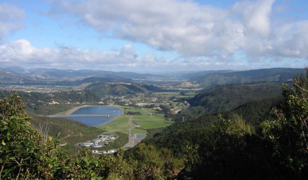
The Macaskill storage lakes, part of the Wellington, New Zealand, water supply system.
Here are three ways we’ve used science in the Wellington Water Supply Resilience Study project to help deliver potable water should a large earthquake strike.
What to do: Identify optimal locations for emergency water distribution points, so they are within walking distance of almost all residential properties.
How we’re doing it: In Wellington, we developed a program to analyze the road and walkway network and find the best route between each property and all distribution points. The best route may be the shortest, or the flattest, or somewhere in between.
At a glance you can then see which areas are under- or over-serviced and adjust the location of the proposed distribution points where possible.
Wellington, New Zealand, has a population of a little more than 200,000. It sits near the Wellington Fault, which has a 1-in-10 chance of moving in the next 100 years.
What to do: Use geospatial data to help categorise which pipes in your network have the best chance to remain functional following an earthquake.
How we’re doing it: For the community of Wellington, we developed a custom-made geospatial program to categorize pipes initially as either resilient or non-resilient based on material and ground hazards captured in GIS (geographic information system). Other subsequent categories included age, diameter, peak ground velocity or shaking, and permanent ground deformation.
What to do: Once you’ve categorized your pipes, you need to determine the best route to connect reservoirs with critical users and distributions points. Choosing a single route out of a complex looped network is not easy to do by eye. We developed a second program to determine the best route so non-resilient pipes are avoided. Taking this approach will ultimately minimize rehabilitation works, disruption, and costs.
How we’re doing it: In Wellington, we reviewed the network to ensure that it was not only hydraulically sensible but also operationally straightforward and easy to isolate from the rest of the predetermined non-resilient network.
The location, magnitude, and effects of earthquakes are inherently unpredictable. By using science, we give our ourselves the best chance to design, build and/or maintain a resilient network of pipes to help continue the delivery potable water after the earth shakes.
It makes sense to take time on International Day for Disaster Reduction to reflect on progress that’s been made on critical infrastructure projects, and to look to the next step in resiliency.