Flash floods: Predicting the most difficult type of flood risk
March 26, 2024
March 26, 2024
New data science approaches are helping us to understand the risks flash floods pose to lives and property
Even well-prepared city planners, property investors, and developers can get caught off guard when areas that aren’t supposed to flood, well, flood.
Imagine you’re a real estate developer who’s suddenly deluged with angry calls from homeowners who bought into a property you developed. These are people you assured, based on the most up-to-date flood maps, that their homes were outside the flood zone of nearby rivers and streams. But now, they’re getting water in their basements. And they’re not happy.
So, what went wrong?
It could be that the flood risk modeling used to calculate risk for those areas failed to account for all three types of flood damage. Here is a look at those flood types.
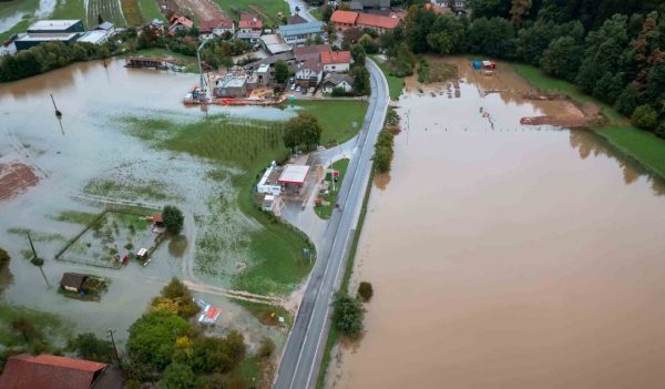
Flash flooding can happen virtually anywhere that gets rainfall—which is most of the planet. It is the least understood of three types of flooding.
Changing weather patterns are bringing more intense rainstorms to areas where the weather has historically been relatively mild. With that, we suspect that flash flooding will continue to show up in more headlines.
In fact, recent research suggests that the cumulative direct damage to property from flash floods now equals or exceeds damage from river and coastal floods. And, compared to other flood types, flash flooding accounts for 60 percent of non-hurricane flood insurance claims in the US.
In many cases, flash flooding combines with other factors to heighten the impact of flood damage. For example, an analysis of Hurricane Harvey claims showed that ZIP codes with higher-than-expected losses tended to have high percentages of pluvial flooding claims.
Flash flooding accounts for 60 percent of non-hurricane flood insurance claims in the US.
People often downplay flash flooding. People living close to shorelines, or close to rivers and streams with a history of flooding, may at least be aware of the risk that they are facing. But flash flooding can happen almost anywhere that gets rainfall—which is most of the planet.
For a variety of reasons, many communities that are far from shorelines and watercourses don’t factor flash flooding into their decision-making. For one, flash flood modeling is complex and requires detailed data on elevation and land use, which is often sparse or outdated. In addition, validating computer models with real-world floods is challenging. This is due to the difficulty in obtaining quality images of flooding under cloudy conditions. Without this information, there tends to be insufficient investment in reducing the impact of stormwater with measures like storm sewers, rainwater catchment facilities, rain gardens, green roofs, and permeable pavement.
But flash flooding can be deadly. In 2021, the city of Waverly, Tennessee, received 21 inches of rain in one day, leading to historic flash flooding. Twenty people lost their lives. Homes, schools, churches, and businesses were destroyed. The community was forever altered.
In areas around the globe, we now have more accurate data on topography, soil types, vegetation, land use, and other factors that impact pluvial flood risk. Better weather forecasting means it’s easier to predict how much rain will fall, how quickly, and when.
Today’s computer systems, accessing cloud-based data, are better able to generate and run complex models quickly and easily. Machine learning through models such as Stantec’s Flood Predictor learn from “gold-standard” physics-based models to predict aspects of a flood. This wasn’t possible before. For example, previous flood modeling solutions could say that a river in a drainage basin was likely to overtop its banks under a given storm scenario. But there would be little information about where in the basin that flooding would occur or where the water would go. In a system like Flood Predictor, we can model where a flood might occur in any location and the expected depth of flood water based on forecasted rainfalls.
Following the disaster in Waverly, we ran a simulation using Flood Predictor. We looked into an area that was heavily impacted by the rainfall. Based on pre-disaster data, the prediction was almost identical to the actual flooding that occurred there. Armed with that kind of knowledge before—and even during—an event can help emergency managers and officials make critical decisions on the fly about where and when to deploy resources.
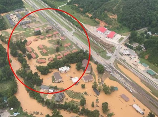
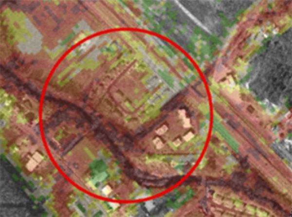
In 2021, the city of Waverly, Tennessee, received 21 inches of rain in one day, leading to historic flash flooding. Top image shows one area of flooding in the community. Bottom image shows Flood Predictor simulation of the Waverly flood. The simulation was run after the flood to show the value of its predictive powers.
From a timing perspective, there’s been great improvement in the speed at which these models can produce results. Timelines have shrunk from months to hours or even minutes. This is particularly important in cases when current weather forecasts are included as part of the data the model works from. It’s now practical for emergency planners and municipal authorities to get real-time predictions of the extent, timing, and depth of flash flooding. This helps them make informed decisions about which areas are most at risk and where to evacuate residents.
It’s also possible for planners to test out various “what-if” scenarios about possible flood-mitigation steps. This helps them see what will be sufficient to reduce flood risk to an acceptable level. Previously, flood-modeling programs took too long and cost too much to allow this kind of what-if, near real-time planning to be practical.
Finally, there are more accurate predictions around how pluvial (flash) and fluvial flooding interact. This is when pluvial floodwater flows into watercourses to become fluvial floodwater. This is exactly what happened with the flash flooding in and around Waverly. The intense rainfall led to flash flooding, which contributed to an overflow of local creeks (fluvial flooding). Predictions about pluvial flooding can also inform the steps taken to manage fluvial flooding.
We can apply this improved ability to model flash flooding in many ways. If a storm is coming, it is now possible to determine the likelihood of a resulting flood. In addition, we can run different scenarios around the amount of expected rainfall to estimate the size, depth, and duration of a flood.
We can also apply it to real estate investments and determine how susceptible a property is to flooding now and in a future full of more extreme weather. One other application is in designing mitigation steps that are sufficient to managing flash flood water and evaluating the effectiveness of existing measures.
Better weather forecasting means it’s easier to predict how much rain will fall, how quickly, and when.
Better flash flood prediction is pulling this overlooked flood type into the spotlight. Here are some steps you can take to benefit most from this increased understanding of flash floods:
Understand the impacts: Flash floods may be of short duration, but the damage can be permanent. It’s important to have a grasp on the relationship between pluvial and fluvial flooding. For instance, the devastating Nashville Flood of 2010 started with intense rainfall over three to four days, which led to fluvial flooding from the Cumberland River.
Understand what’s changing: There are several factors, such as an increase in extreme weather events, that are causing flash flooding to become more of a risk.
Consider new at-risk areas: Consider what areas in your community (or property portfolio) are not at risk from fluvial or coastal flooding but may be at increased risk from flash flooding.
Stantec’s Flood Predictor is being used in states like Tennessee and Kentucky right now. It’s helping to provide community leaders with high-quality flood predictions and help them make more accurate, timely decisions in support of their disaster planning and hazard mitigation efforts.


