Flood risk modelling using machine learning helps protect communities. Here’s how.
November 29, 2023
November 29, 2023
Using generative AI and probabilistic results, new flood risk models can quickly map the impacts of pluvial or flash flooding
Community leaders, emergency responders, and property owners all want to know: will I get accurate and timely warning if a flood is going to happen? They feel that with adequate warning, they will have a chance to protect their property and get themselves and their families to safety. Without a warning, loss of property and life can be catastrophic.
So, in a world where generative AI can leverage data to predict anything from stock prices to sports scores, how’s that going with predicting floods?
Emergency planners want to avoid two extremes:
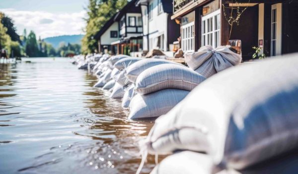
Without warning, a flood can bring catastrophic loss of property and life.
To understand the benefits of today’s flood modelling, it’s best to first understand how it’s been done historically, and how current technology does the job better.
Traditionally, engineers have carried out flood mapping using methods not much changed from precomputer times. They’d use field survey techniques to take a series of cross-sections of the drainage basin and interpolate—or guess at—the points in between.
It was slow and costly, and as a result only a limited numbers of scenarios could be considered—perhaps a 10-year flood and a 100-year flood—at a time. It focused on “fluvial” flooding in which a watercourse burst its banks. And wasn’t viable for modelling “pluvial” (or flash) flooding, when intense precipitation covers the ground, unrelated to a watercourse.
These traditional approaches provided binary answers—an area was either “inside” or “outside” a line on a map indicating a flood zone. In some cases, people with flooded properties outside those lines were left puzzled, frustrated, and angry: “We thought our house was in a safe place!”
Today’s computers can handle much larger data models and produce useful results more quickly than ever before.
Now, better help is available. Flood modellers have much more powerful tools, like Google’s FloodHub and Stantec’s Flood Predictor to do their jobs. Tools like these improve flood prediction in at least three ways:
Powerful tools, including Stantec’s Flood Predictor, help flood modelers improve flood prediction.
One of the great benefits of these advancements is the ability to provide probabilistic results. Much like your local weather forecast, we can now assign percentage likelihood to various flood scenarios and make more contextual decisions than ever before.
Probabilistic results are really a game changer. They can help property owners understand that if they build or buy in a specific place what their flood risk will be in a variety of possible scenarios. It also helps decide what steps they can take to mitigate those risks.
These models can also help municipal governments know what kinds of development should be built in a flood plain. Perhaps a designated area is best suited for sports and recreation facilities but not residences. Or certain kinds of development could be approved, provided mitigation steps such as a raised building footprint, are included.
Just as it’s important to understand what today’s flood modelling systems can do, it’s equally important to understand what they can’t.
In many models such as Google’s FloodHub, there is still a strong focus on riverine—or fluvial—flooding. At present, this limits the tool’s use to only one type of flood risk. By contrast, Stantec’s Flood Predictor models both riverine flooding and pluvial flooding, offering users a wider view of potential flood risks.
Some flood models focus on flood risk at specific locations. For example, FloodHub uses AI to provide SMS alerts about timing and height of river flooding. People living beside those rivers can receive warning if their community is at risk from rising waters. Stantec’s Flood Predictor, by contrast, can provide flood risk data for specific locations or for wider geographic areas once a community invests in a flood model.
Emerging technologies will continue to help municipalities predict flooding and enact protection measures.
In the future, we expect to see greater ability of flood modelling to reflect reality.
This includes the ability to model velocity of water, as well as the effects of debris—including tree branches and logs, and sediment load. There will be the ability to model combined risks from more than one source of flooding. We’ll also be able to model the effects of various mitigation measures such as stormwater improvements and catchment basins.
We’re already seeing benefits from combining detailed data with technologies such as active learning and machine learning (AL/ML). Using those tools, the program can learn from experience and direction of the operator. This can help predict the probability of flood events in cases where there are gaps in traditional methods or due to changes in climate, including patterns of precipitation. Current technology can use AL/ML to produce more realistic results within minutes.
Going forward, municipal leaders will continue to have greater confidence that their communities won’t be surprised by unexpected flooding. They’ll have less fear of losing community trust by enacting flood protection measures that turn out to be unneeded. This means better protection of lives, property, and infrastructure from the risk of flooding.

